 |
|
India Nepal and Bhutan December 2010-January 2011
How it All Came About Having decided that I would take a break from overseas motorcycling to devote more time and resources to exploring the Australian Outback (after my Big Trip North and Mt Isa and the Gulf), I was introduced during the Dalmatia trip earlier in 2010 to a new, re-jigged itinerary that combined Nepal and Bhutan into one trip, with a few days transitting India. It was Ferris Wheels new Shangri-La tour. My reaction was that this would be the perfect trip to share with my 13 year old grandson, Dylan, who loves riding on the back of the bike with his granddad and has travelled with me on a few trips in Oz (see Riding with my Grandson). At Dylans initiative, we planned to leave ahead of the scheduled trip to spend a couple of days exploring Delhi and visiting the Taj Mahal in Agra. Preparations In preparation for the trip, I prepared a rough guide a very rough one to the tour. Its purpose was to set out some of the highlights in more detail. You can find it here. I also prepared a simplified, easier-to-read guide for Dylan - just a short page or less for each place of interest.; and a few pages on historical and cultural issues. That might appeal to someone who wants a quick virtual tour or a feel for what the tour provided. I called it Dylan's Guide.
Something that caught my attention was an ABC News item on 12 November on paragliding at Pokhara. Check out this news item on paragliding vultures at Pokhara, Nepal. This was what got us both interestested in parahawking; and lead to our booking ahead to do it. Apart from the interest aroused by watching the movie Little Buddha and coming across the ABC story about parahawking in Paro, Nepal, we decided to rise to the challenge of bringing clothes to the charity in Brijghat on the Ganges that Ferris Wheels supports. The practice is generally for participants to add a few kilograms extra to their luggage. However, both our airlines (Virgin Blue and Singapore Airlines) responded positively to my request for an extra 20-23kgs for us to transport the clothes. The quick and generous response from Dylans family and my cycle group delivered us 40kgs of clothing. Virgin Blue immediately met the additional request and authorised 40kgs excess. Singapore had an issue with an already over-booked flight because of the change of aircraft from the originally scheduled A380 (with its engine problems) and didnt want to authorise the extra excess up front; but when we turned up in Sydney with the 40kgs, they readily agreed to carry it and upgraded us to business class, although I dont think the two decisions were necessarily linked. For Dylan, preparations also included four sets of inoculations against this and that, obtaining a passport, getting visas for India, Nepal and Bhutan, being introduced to curries, and getting to understand whats ahead of him in terms of places, people, monuments, history, geography etc. It was all very exciting for him. He tackled everything enthusiastically and mastered more than many a tourist might. Dylans Introduction to India: Delhi
The Red Fort, a product of the Mughal Emperor Shah Jahan, provided Dylans first encounter with the many Mughal treasures of India; and he was far from disappointed. He marvelled at the grandeur and was eager to cover it all. We mingled with a couple of school excursions and Dylan soon found himself the centre of attention as they grouped around him to ask him his name and where he came from a phenomenon that would be repeated several times over the ensuing days. The near-by Jama Masjid, Indias largest mosque and another product of Mughal emperor Shah Jahan, was reached by rickshaw the pedal sort. You sure get to appreciate the leg work that the poor driver has to exert on the up-hill sections. The mosque has a huge courtyard and dominating minarets, one of which you can ascend to the very top; and we did. Both these Mughal-era sites are in the heart of Old Delhi. The main focal point of Old Delhi is Chandi Chowk a long, crowded street of shops, stalls, vendors and people. We pretty much covered the full length on foot. Fortunately, Im sure Dylan thought, there was a Maccas half way along. The Maccas are strictly free of pork and beef. Dylan had his usual chicken nuggets and I had a Veggie Mac, the only sort available.
Our remaining task for the day was to get into our securely padlocked luggage without the keys, which were presumably on the kitchen bench at home with my mobile phone. After wandering the local Karol Bagh markets without finding a solution, we eventually resorted to prevailing on the hotel to be a bit more imaginative than they had been late the previous night. One of the wallahs went out and bought a fearsome saw blade of some sort or other. He spent a long time, going through two blades and scraping fingers, cutting through the padlocks. But, at least, by the end of the day we had access to our luggage. The next day had us back on the Metro to the amazing complex of Swaminarayan Akshardham. Thats a mouthful, but the central concepts, deities and gurus of Hinduism, including its various sects, all have names unfamiliar to the non-Hindu world. This complex has absolutely mind-boggling architecture, sculptures, and religious motifs in the traditional Hindu intricacy. Unfortunately, photography was strictly forbidden. That was disappointing, but the visit was none the less absorbing.
Back into a tuk-tuk for a visit to Humayuns Tomb another of Indias many World Heritage Sites (we visited five or six such declared sites over three days!). Humayuns Tomb was the highlight of the day. Its a large complex with several tombs and other monuments. The whole site was absorbing; and the actual tomb of Humayum was truly grand. All of it had Dylan quite taken by its size and significance, even though he was also fascinated by the squirrels. Humayun was the second Mughal Emperor of India. His tomb was built by his widow in 1569-70, 14 years after his death. The tomb is considered a landmark in the development of Mughal architecture and the earliest extant example of the Mughal tradition of the garden tomb. The complex was later used for the burial of various members of the ruling family and contains some 150 graves. It has been described as the necropolis of the Mughal dynasty. It was well after 6.00pm by the time we got back to the hotel, making it a very long day but nothing compared to what we had awaiting us on the morrow. I have published a separate page on Delhi and Agra that combines this visit and my subsequent visit as part of my Himalaya tour. Agra: Taj Mahal, Agra Fort and Fatephur Sikri It was a 5.15am pick-up from the hotel to catch a 6.15am Shantabdi Express to Agra. In company with Russell, another of the Ferris group who had also arrived ahead of the tour, we had a car and guide the whole day to take us to the Taj Mahal, the Agra Fort (also called the Red Fort), and Fatephur Sikri. I had initially worried about the expected three or four hours we might have to kill before catching the return train at 8.30pm; but that was an ill-conceived worry. We got back to the station at about 8.00pm, having arrived at 8.30am that morning!
The sight and experience of the Taj are unique. It has a magnetism and fascination that is likely the equal of no other world monument or natural feature. Its special interior appeal is its beautifully executed marble with intricate and delicate designs of in-laid semi-precious stones. The Agra Fort, built of red sand stone and hence shares the name of Red Fort with its counterpart in Delhi, was a creation of Akbar, the most famous and influential of the Mughal emperors. It was the centre-piece of his capital at Agra. It was both a military bastion and royal palace; a sprawling city in its own right, surrounded by a moat and several levels of defensive fortifications. Its size and grandeur were innumerable levels above the Red Fort of Delhi, but, in fairness, the Agra Fort had many different functions. Fatephur Sikri was another creation of Akbar. It was to be his new capital, located and dedicated in honour of a guru who was attributed to bringing him the blessing of a son and heir. The city took 15 years to build and another 14 years to recognise that it didnt have a reliable source of water. It was abandoned and left to decay. Much of the 11km U-shaped wall still stands, the large lake that bordered the top of the U has long gone, as have most of its buildings; leaving only the royal palace complex and adjacent mosque and tomb of the guru standing. Its all pretty amazing. Back in Delhi for the Motorcycles
However, the afternoon was Meeting the Royal Enfields time. And thats what we did. It included lessons on the vagaries of this historical bike; test runs around the car park; a traditional Hindu blessing invoking the protection of Lord Ganesha, the elephant-headed deity (performed by Lali Singh, a Sikh, owner of the bikes); and general meeting of one another and our support team. Heading out from Delhi
It was a special event to see and cross the Ganges. The Ganges is something very special in Indian history and culture; and in Hindu religious traditions and beliefs. The Ganges rises in the Himalaya Mountains and flows 2,500kms to the great delta in Bangladesh. It has the largest volume of water of any river in India. Hindus regard the Ganges as the holiest of rivers. It was named after the goddess Ganga, the daughter of the mountain god Himalaya. Bathing in the river is believed to wash away one's sins. To bathe in the Ganga is a lifelong ambition for Hindus.
It is also important as a national river. Many former imperial capitals were located on its banks. We crossed the holy Ganges and continued our journey to the hill station of Nainital. Somehow, calculations of time to cover the distance had gone awry. This lead to covering the last 30kms in the dark. That might not sound too much of a problem, except that these 30kms were the climb to the hill station a narrow, constantly winding, twisting road with several longish stretches of rough, rocky gravel road and high beam headlights of trucks coming at you. It took a couple of hours to make the climb and gladly welcome Nainital. The road to Nepal The compensation for the nightmare of the evening before was to retrace our path back down to the lower plains in daylight. Even short distances on maps can take a disproportionately long time to cover on pot-holed roads, any number of road work diversions and in teeming traffic which jams to standstills in every town you pass through. Despite that we got to the India/Nepal border at a reasonable time. The processes were slow on both sides and added a delay of more than two hours to the timing for the days ride. Traffic in Nepal was less confronting but there were enough trucks to hinder progress, especially as darkness soon engulfed us along the Mahendra Hwy that crosses the whole of Nepal east and west. It was after 8.00pm before we finally regrouped at the turn-off to Bardia National Park. That was something of a relief as its impossible for all the bikes to stay together; and travelling long, dark roads, with no one anywhere to be seen, can be very daunting. At least, I found it so. There is a system of corner marking and a tail-end Charlie, but its not infallible and I found I was constantly wondering if something had gone wrong. Bardia National Park
A late, exhausted night was followed by a very early start for elephant rides into the jungle and plains of the national park. The elephants lumbered their way down a river bank and across a (much deeper) river, with a 2-year-old calf having to swim alongside Mum to manage the depth. We didnt see any of the famed Bengal tigers but we caught a glimpse of a native antelope scurrying through the thick bush. The river crossing on the way out was more fun in daylight. Incongruously, I made a better job of it in the dark, if a reasonable benchmark of success is how far up your trouser leg got wet. The night before it was less than half way up my carves. The following morning it was half way up my thighs. At least Dylan and I emerged with bike upright and moving until it stalled with the back wheel about 10cms out of the water. Into the High Country
Sadly, being so late and with another long day to follow, we didnt get to spend any time at the Buddhist monastery or monument commemorating Buddhas birthplace. A thick fog prevented even a glimpse of it. After making our way back to the bustling town of Butwal that we had come through the previous night, we then commenced our climb into the high hills of central Nepal. As you can see from the map on this page, especially in terrain mode, there is a strip of low land along the southern border the Terai; with the central part a maze of hills and valleys, followed by the Himalayas along the northern border. Although we had only 200kms to cover for the day, it still took all day, but thankfully we got to Pokhara before the sun set, but only just!
We werent disappointed by the first views of the Himalayas as we got closer to Pokhara.
But the highlight of this resort town was to be the parahawking. This essentially is paragliding with an accompanying vulture (Egyptian Vultures, which, despite the name, are indigenous to the area as they are to many parts of Asia and Africa). Our arrival in Pokhara on 23 December offered an initial opportunity to wander down the very tourist-oriented main street to dine in one of the many establishments providing any variety of meal choices.
An extra bonus was having a vulture each. There are only two vultures trained to land on the arms of the paragliders. So usually one does the morning run with two paragliders; and the other does the afternoon run with two paragliders. The vultures are Kevin and Bob. Partly because of our different weights (leading to different altitudes) and partly because of the two planned lay days (=no exercise for the vultures), they brought both Kevin and Bob for us each carried in the taxis we took from Pokhara to Sarangkot, higher up in the surrounding hills. It was a great treat, with wonderful views of the Himalayas in the background. That evening Christmas Eve was, in effect, our Christmas, in keeping with the traditions of many countries that celebrate Christmas on Christmas Eve. We had a fine, celebratory dinner in a local restaurant; and we even had a Santa Clause. The next day was a pretty straight-forward run to Kathmandu, the capital of Nepal. Kathmandu
We then had a full day to explore Kathmandu. Most of the morning was taken up with a flight along the Himalaya peaks. The plane kept south, as north of the range is China. Between everyone having window seats and being brought up in turn to the flight deck, we all got good views of the amazing Himalaya mountains, dominated by Mt Everest. In the afternoon, a few of us set out to visit the main attractions of Kathmandu itself. These were the temple complexes (World Heritage sites) at Durbar Square in the centre of town and the Swayambhu Stupa high up on a hill overlooking Kathmandu. Both were great experiences. Durbar Square is the religious and social heart of Kathmandus old city and is a complex of palaces, temples, shrines, statues and courtyards built between the 12th and 18th centuries by the ancient kings of Nepal.
The shorter way of 130km took us over 7 hours. The climb was relentless. The switchbacks merged into zig-zags, as the road wound its way up, across and between the many precipitous ridges. The peak was 2,400m. Then the long winding way down the other side.
The ride up provided several glimpses of the Himalayas, with the top of the range exposing a view of the length of the Himalayan range. We eventually descended into Hetauda as dusk. The other six bikes, with a later start, made their way along the longer but quicker route and pretty much arrived at the same time as we did. From Hetauda, we had a long 260km highway ride along Nepals Terai (the low-land plains along the southern border). Dylan made a good choice to ride in the bus. He was dead beat. He slept most of the time and still slept soundly that night at Biratnagar. This was followed by a shorter but again highway ride to the border with India. We crossed back into India ended up in the town of Siliguri. Darjeeling
The Elgin Hotel in Darjeeling is an old British colonial establishment, which still proudly preserves all the hallmarks of the era of the British Raj. Its lavish. Its setting is spectacular. Darjeeling, of course, apart from being famous for its tea, was a renowned hill station during the British Raj a summer retreat to the cool of the high altitudes to escape the suffocating heat and humidity of the lowlands and coastal areas. In fact, it became the summer capital of the Raj when the capital was in Calcutta.
On the brighter side, the back road was an enjoyable ride on a reasonably good surface (mostly) and without the constant challenge of Tata trucks and long wheel-based busses. The views of Darjeeling from several kilometres out were enticing. You could see the town nestled on and around a ridge, with the Himalayas as a backdrop. They included the worlds third highest mountain Kangchenjunga. On arriving in Darjeeling, we dropped into the town square, browsed shops galore, and tested the Tibetan bazaar (lots of stalls run by Tibetan refugees). Dylan became engrossed with the Tibetan meditation bowl, which he insisted on buying. I then spent a lot of the next two nights listening to its ringing tone (a bit like the wine glass ring). Darjeeling is nestled on and around a high, steeply-sided ridge. The town square occupies a large flat area just below the peak of the ridge. From the town square a wide pedestrian mall encircles the peak of the ridge, returning to the square. Within the encirclement, higher on the ridge stands the old English church of St Andrews, whose bell tower clock chimes every quarter hour and can be heard across the town centre.
Later in the morning, after a later start than the group, Dylan and I visited the local zoo, attracted mainly by the elusive snow leopard; and the mountaineering institute, set up by Tensing Norgay, who accompanied Edmund Hilary to the top of Mt Everest in 1953 becoming the first to reach the summit. The institute contains a lot of the gear used in that first ascent to the summit by Hilary and Norgay. Norgay was a native of Darjeeling and his ashes are entombed in the institute grounds. In the afternoon we did a toy run on the bikes to a refuge for mentally disabled people run by the Sisters of Charity. We all bought and brought gifts of various sorts. Most of the inmates were adult women whose glowing faces and overt pleasure at receiving even the simplest of presents made the trip a very emotional but rewarding experience. The Elgin Hotel had an elaborate New Years Eve party planned. Bon fires and cocktails in the garden at 7.30pm; a cultural event in the gardens pagoda (local singing and dancing troupe); dinner at 9.00pm with all the tables lavishly decorated; followed by a DJ-led night of dancing. Then, after midnight, their own fireworks, with Dylan soon into the fray with hotel staff lighting them. Into Bhutan
With the highway came the inevitable load of trucks and other traffic, but we encountered that on every trunk road in India. Frustratingly, it was on this more easily manageable section that, making our way up the line of a convoy of army trucks, lead to a second drop of the bike. It was a harder fall for me, but Dylan bounced lightly, although not without a telling scrape on his helmet and a few sore muscles next day. I confined myself to the bus for a few days with either a bruised or possibly cracked rib and swollen ankle. Dylan was all for getting back on the bike there and then; but that wasnt an option for his driver! We arrived late in the afternoon at the border and crossed into Bhutan to the town of Phoensholing for the night. Although it was dark by the time we arrived, it wasnt long before Dylan had met some of the local kids around his own age and began several active games in the street. I had to call him in for dinner; and again after dinner to go to bed. Paro
Although the ride in the small and comfortable bus was made less comfortable by nursing painful bolts at every bump, I couldnt help feeling that managing the narrow, climbing road, with any number of landslides that had all but taken the road with them, would have been a stressful challenge. While most of the group were revelling in the challenge of the roads and conditions, I had already begun to feel the strain of long exhausting days. But there was no stopping Dylan. From the time of a late lunch stop, there was filming to do by camera man Robin from the back of Mikes bike, so Dylan negotiated with Pinky, one of our mechanics, who was riding tail-end Charlie, to go the rest of the way with him. The drive/ride into Paro saw us come into a very wide, flat valley no doubt the main reason why Paro has Bhutans only airport. It dominates the approach to the town. O The Paro Dzong, also called the Rinpung Dzong, was originally built in the 17th century to defend the valley from Tibetan invaders. It was also used from the outset as the administrative and monastic centre of the western region; and was traditionally called the Rinpung Dzong. Below the dzong, providing access from the town, is a typically Bhutanese cantilever bridge. These bridges seem to be part of all dzongs, which were often built alongside a protective river.
Another highlight of Paro was Tigers Nest monastery. We had both been looking forward to making the 4 hour walk up and back, climbing the 1,200m vertical ascent from the bottom to top. I had even brought some of my cycling energy boosters to help ensure I didnt run out of puff before reaching the top. But a climb to Tigers Nest was off the agenda for me. Dylan set out with most of the group, who were committed to the feat. As it turned out, he, along with most others, hired a horse that could get to a point a little above the monastery on a neighbouring ridge, leaving the rider to walk down a deep dip before climbing up to the monastery. Being interviewed on camera much later into the trip, Dylan cited Tigers Nest and parahawking as the two most memorable highlights of the tour. Thimpu
We arrived by lunch time and had the afternoon to visit the citys central stupa and see the city from a high vantage point just below the huge Buddha statue overlooking the whole valley. We also visited a wildlife reserve which housed several Bhutanese Takin. According to Bhutans religious mythology, Lama Drukpa Kuenlay, the divine madman, ate a cow and a goat, leaving only the bones. He then stuck the goats head on the bones of the cow; and upon his command, the animal came to life. Thus was created the Takin.
Punakha was the capital of Bhutan until the 1960s. In 1907, Punakha Dzong had been the site of the coronation of the first king of Bhutan. It retains current significance as the winter home of Bhutans central monastic body led by Je Khenpo. We spent some time exploring the magnificent architecture of the dzong and the solemnity of its monastery, in which religious ceremonies were being conducted. However, before we could enjoy the impact of the Punakha Dzong, we had to climb the high Dochu La (Dochu Pass) soon after leaving Thimpu. I hadnt known that La simply meant Pass. I had always assumed it was something far more exotic, as in Shangri La. However, in Bhutan the pass has a lot of significance. Each pass (the high point of crossing a mountain range) is marked by chortens, stupas, shrines and prayer flags. (Chorten is a Tibetan word which, in effect, is a smaller stupa-like structure. Chortens are very common throughout Bhutan.) Dochu La had over 100 chortens and several shines and sets of prayer flags, as well as several vantage points providing spectacular views of the Himalayas. It also included a restaurant that provided a welcome chai stop. It also had lots of snowy and icy roads on the ascent and descent. The Kichu resort that night would be a great summer resort, but, as nice as was the setting, it wasnt exactly an ideal winter resort; although, once we got the hang of turning on the hot water geysers, we could at least enjoy hot showers. Trongsa
As we passed over Pele La, with its chorten and prayer flags, the day brought great views of Mt Jhomolhari, a sacred mountain in Bhutanese history and tradition. A planned visit to Trongsa Dzong had to be foregone to avoid a night time arrival into Bumthang that evening. While some were obviously unfazed even relieved by this disappointment, I would have liked to visit it, even though it came up soon after the Punakha Dzong. Trongsa is one of Bhutans most historic towns. The first monastery was built there in 1543. The dzong, constructed in 1644, is said to be described as a dragon flying over mountain peaks. According to the literature, in addition to the dzong, the town has a lot of tourist interest, including its three-storey white traditional houses, its local weaving from hand-dyed wool and its Tibetan bazaars. We did get the opportunity to view the dzong from various vantage points and to drive through the town; and, importantly, we arrived in the Bumthang area before dark.
Our stop-over was Chamkhar, a small village or district of Jakar (wasnt sure which). The area was dominated by the Jakar Dzong, which we got to see next morning spectacularly overlooking the Chamkhar Valley. Thrumsing La One point of particular interest in the ride/drive from Chamkar to Mongar was the fact that most of the say was spent at higher altitudes that the highest point in Australia. Mt Kosciuszko is about 2,200m (7,300ft). We spent most of the day higher than 3,000m, culminating in crossing Thrumsing La at almost 3,800m (12,400ft). We had a couple of altitude sickness cases, but I dont think too many of us even bothered with the altitude medication. Neither Dylan nor I had any adverse reactions to the altitude. Incongruously, crossing the highest pass in the country, with any amount of snow and ice sections, did not bring down a single bike. Was it improved skills or the luck of no black ice? In any event, the climb over Thrumsing La was thoroughly enjoyable, albeit in the bus (for both of us again this day). The enjoyment was enhanced by the views on the way up of Bhutans highest mountain, Mt Gangkhar Puensum (at 7,500m). Mongar to Trashigang
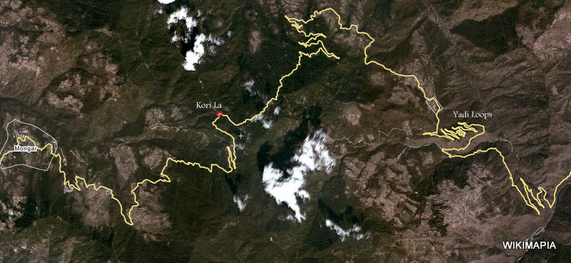
It worked fine; and I had a great ride day. Not that it seemed that way early in the ride. In contrast to an ill-founded expectation of no more ice passes, it wasnt long into the ride before we started the ascent to Kori La (2400m) decked out with prayer walls and prayer flags. The ride up was safe enough despite stretches of snow and ice. I guess you start to assume all such stretches would be similar; but that wasnt to be. The very first such stretch on the descent brought down three bikes in quick succession, as black ice suddenly revealed itself lurking deceptively in the wheel tracks. Fortunately, I was well back in the pack and had the benefit of others close analysis of how to proceed. It still took some time and contemplation before I was mentally ready to go. The key was to stay off the road and edge along the half metre wide shoulder, over the frost and through the potholes, but steering judiciously between the black-iced bitumen to your right and the long, perpendicular drop to your left. It worked fine. Although there continued to be ice patches as the road switched back and forth as it made its way down through the forests, they remained victimless. The descent was steep and included the Yadi hairpins (Im not sure I consciously took them in at the time!). Once out of danger, as it were, the road traversed a few more switchbacks before it flowed into the Sheri Chhu Valley that took you to the Drangme Chhu (river). From here, it was mostly a gently curving road, clinging to the steep hill sides high up above the river, winding in and out of side valleys until it finally turned off on a short diversion to Trashigang. It was both a relief and a pleasure to arrive in Trashigang, having had a safe and enjoyable ride. Dylan had been happy to let me ride alone on the first day back on the bike. Mind you, he had not missed too many days on a bike. Trashigang was a small, pretty town, with a river running through it, an upper market and a lower market, steep streets and precariously placed houses and hotels. Our hotel was sitting on the edge of a ridge, with valleys on either side; and a great view of the local dzong. Unfortunately, the Google Map doesnt provide a very good or even accurate depiction of the road. Here is a better depiction provided by Wikimapia.
Last Day in Bhutan Our last days ride in Bhutan would be a long one of 180kms. And through more mountainous territory before reaching the lowlands at the very end Samdrup Jongkhar, the Bhutanese border town.
Even the more benign mountains, however, provided their own challenges, as layer upon layer of road struggled up and trickled down mountain sides, with the usual hazardous tight turns linking each layer. The real surprise came about between the 45km and 40km milestones (to Samdrup Jongkhar). It started with the inevitably expected road works usually as a result of monsoon landslides. But somehow, this time, it seemed different. The road quickly turned into a rougher than usual set of wheel tracks that all but disappeared into muddy quagmires, deep water-filled potholes and recently excavated landslide rubble. Whenever you felt the end must be just around the corner, the tracks, euphemistically called such, often deteriorated further into barely recognisable traces over piles of rubble and around immovable rock falls. The best it got was the emergence of something that could reasonably be called a road but whose surface was a maze of craters, lumps of rock and loose stones on the innumerable tight corners that brought us all the way down to Samdrup Jongkhar. I didnt mind this segment; actually, enjoyed it to a point. I felt more comfortable in it than coping with constantly winding, icy mountain roads. But I was pleased not to have a pillion; and consoled that Dylan didnt have to cope with such an ordeal. Ha! About 20mins after arriving at Samdrup Jongkhar, in comes Dylan gleefully on the back of Mikes bike, having not only endured (=enjoyed) the last 40kms but ridden with him over the passes. He was ecstatic at the days adventurous riding! At different times during the course of our travel through Bhutan, we came across archery and darts competitions along the side of the road. Both are considered Bhutanese national sports. Archery, in particular, ranks high on the list of national pastimes. On the two occasions we saw the competitions, the contestants were colourfully decked out in national garb; and after each round of shots, they came together in a sort of celebratory song and dance to acknowledge the winner of the round. It was all quite ceremonial. The bows used in the archery competition were no longer the traditional bamboo bows. They were modern 'composite' bows. The darts, however, were far more traditional, being very large and being thrown a great distance to hit a ground-based target. There are photos of the competitions in the slide show below. Finish in India
I dont know why I imagined that; but it certainly wasnt to be. Although the road from Guwahati into Bhutan would have to be a major trade and supply thoroughfare, it was mostly rough gravel for almost half the 100kms. After that, the surface was okay, but theres always the unexpected jam. This time due to a road blocked by collided Tata trucks. Theres a certain ingenuity with Indian drivers. You simply make a new lane...until that comes to a standstill because of in-coming traffic. Then you make a new one again...this time being replicated by the on-coming traffic...until all lanes in both directions have absolutely nowhere to go. Except that the bike riders (and a few more flexible cars not always successfully) could mount the half metre or so embankment onto a broad, flat sand platform. Which is precisely what we did much to my consternation and Dylans delight. Once past the road congestion, it was back down the embankment and onto the now clear road. That was until we reached the congestion of traffic all vying for a priority place to cross the huge Brahmaputra River, considered one of the worlds greatest rivers; and a major flow into the gigantic delta of Bangladesh. The bridge across it into Guwahati seemed at least a few kilometres. It was hard to tell on the bike, since most of the crossing was spent squeezing between lines of opposing traffic. We reached Guwahati and found our neat hotel tucked away in this seemingly grimy city. It was nice to finish the trip to have a challenging days ride and Dylan on the back, albeit instructing me through the intercom, as he did from Day 1, to dart here or there, go up the left side, get up onto the embankment, overtake NOW. And, of course, in response to frustrations expressed about gear changing, to hear through the intercom its not the bike, Granddad! Farewell to Himalaya
Dylan and I were lucky to have seats on the right hand side, as the plane spent two hours of its flight tracking west along the southern side of the Himalayas over Bhutan and Nepal. We had great views of the Himalayan range along the route. Our Route Here is a map of the tour. There is a noticeable gap in the route in the east of Bhutan between Trashigang and Samdrup Johgkhar. There's just no road on My Maps, but it was there. More or less. That was an amazing ride through landslides and rough mountainous dirt tracks. Little wonder the road's not on My Maps.
Slide Show and Photo Album
This one is a short (9 mins) You Tube slide show mainly focussed on Dylan. It combines photos with short video clips.
This is a more general set of photos of the tour. Here is a photo album of the tour
|


 at Brijghat")


")


")


 The ride from Thimpu to the Kichu resort at Chuzomsa, over-looking the raging Dang Chu River, included a visit to the impressive Dzong of Punakha on the confluence of the Pho Chhu and Mo Chhu rivers. The dzong dates back to the early 1600s.