 |
|
but some equine consolation November, 2017
I thought I would add a bit more adventure to a ride through the New England district by leaving the highway at Scone as I headed north. There were some faint, dotted lines of would-be roads discernible on my Australia Motorcycle Atlas, but the scale doesnt exactly facilitate confident route planning at this level. And its nigh impossible to map out a route on Basecamp or my Garmin Zumo on such roads. You have to zoom in so far before they even appear that by then any perspective has been lost. Besides, the software constantly wants to make you back-track and reach your destination from a different direction.
Its still a tiresome process, tracing the combination of back roads on Google Maps, identifying places of transit; and then finding those places on Basecamp to drop via points. And because of the predilection of the Garmin software to look for better roads, you end up having to put in an excess of such points to ensure you stay on track.
A good deal of the route was following the Isis River. I had no idea that we had a river of such a name or that we had obviously invented the name long before the jihadists of Iraq and Syria. Perhaps we shouldnt confuse Isis and ISIS. I was to later discover that Australia has a few Isis rivers; and that the name is closely associated with the River Thames and Oxford regattas. I had been aware of the Egyptian goddess of the same name.
I was pretty sure my GPS told me to keep going ahead. Besides the road veering to the right and across the river had a signpost saying it was Mountain View Rd which didnt ring any bells for me. According to both Garmin and Google Maps, I should be on Timor Crawney Road. And there was a road-work sign saying No Through Road. Local Traffic Only. That clinched it. I went straight ahead. As it turned out, I stayed on a road identified on Google Maps as Crawney Station Road that doesnt even appear at all on the Basecamp software. A later check of my planned route on Basecamp clearly showed I should have crossed the Rubicon, no Isis, at that point.
As I looked down the other side of the hill it was obvious that I had reached the end of anything resembling a road. By now I guessed that I needed to be on Mountain View Road but that wasnt an option because of the no through road sign. My only way out was to retrace my route until I found a road that gave be access to the New England Highway. Mercifully, one such road came up without having to end up back in Scone. My consolation for the day was some welcome affection from the resident horse. Epilogue Not to be totally outsmarted, I approached Nundle via the Old Wallabadah Road (gravel) coming off Lindsays Gap Road from the New England Highway; but turned south away from Nundle when I reached Crawney Road. Not surprisingly I soon came across a sign saying, you guessed it, No Through Road. Obviously, the road was blocked somewhere on Crawney Pass. I was tempted to keep going to see if a bike could defy the odds, but my rare better judgement prevailed. |
 You can never be too careful. But sometimes it just doesnt matter. And theres often a pot of gold in one form or another even if the rainbow fades prematurely.
 The only saviour is Google Maps. Not only do the roads show up early enough to keep a reasonable perspective, but in satellite mode you can get some idea of what the terrain and countryside are like; and be easily deceived if youre not wary.
 On this trip my destination was Nundle, with roads that took me through Gundy, Timor and across Crawney Pass before sneaking me into the little-used back door to Nundle. It wasnt straight sailing but a piecemeal linking of roads, some of which were not much more than tracks.
  But back to the story. I eventually reached a point where there was the slightest narrow-angled turnoff where one arm crept down a small bank and crossed the Isis River while the other went straight ahead. They both looked much the same in terms of being the road. The roads ran parallel for a while on different sides of the river.
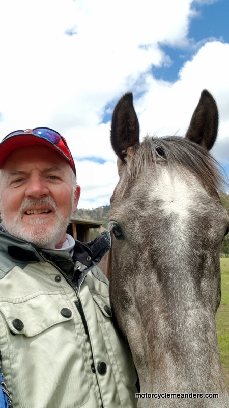 Still I blindly persisted until the road started to look like two-wheel tracks as I reached a summit of sorts and, surprisingly, a large horse yard and stable looking like they were inhabited and currently in use. And sure enough, there to greet me was the resident horse.