 |
|
Sept-Oct 2013
It’s an interesting process getting into Tibet. In fact, there are two alternative processes: one for entry from Nepal and one for entry from anywhere else (invariably via some port-of-call in China but outside Tibet). My original choice was the latter. Together with four friends from previous meanders abroad, the plan was to take the pressurised train on its 48-hour journey from Beijing to Lhasa. That was to follow two and a half weeks touring “mainland” China (for want of a better term since Tibet is also part of China); and would give us a few days in Lhasa before the rest of the motorcycle tour group arrived by plane from Kathmandu. That plan was thwarted by visa issues so we had to fly from Beijing to Kathmandu, re-apply for visas and enter Tibet from Kathmandu.
After flying from Beijing through Guangzhou to Kathmandu, we met up with the rest of the group there and spent a few days getting new visas for China and a special entry permit for Tibet, the latter being an essential requirement in addition to a China visa. The big difference with the Nepal process is that the visa and entry permit come as a package deal – and nothing appears in one’s passport; it’s all in accompanying papers applying to the whole group. Anyway, be all that as it may. The only important thing is that, in the end, it was a straight-forward process in Kathmandu that opened the door for us to enter the timeless land of Tibet. The Tibet Tour was undertaken with Extreme Bike Tours who managed all the visa and entry permit issues in Kathmandu; and guided on the ride across the Tibetan Plateau with expert and influential assistance from our very professional and gregarious Tibet-based guide. Map of Our Route The map is in Satellite mode because it’s more interesting to get a view of the terrain. You can change the map to Map mode to get a better idea of the locations relative to towns. Have fun zooming in and out to appreciate better the nature of the Tibetan Plateau. View Tibet Tour in a larger map
Here is my movie of the tour: once it starts, click on settings (the cog at bottom right of video screen) and select 720HD. Then watch it in full screen. Hope you enjoy it.
Guide to the Tour Prior to the tour, I prepared a short guide, which you can view here. Lhasa: Capital of Tibet
We four harmonious friends should have been arriving in Lhasa by train, but missing that part did not detract from the overall absorption in this unique experience. Dropping in for some extra days in Kathmandu hadn’t been a bad fall-back option.
First impressions of Lhasa itself were of a broad-avenued city with lots of traffic, billboards, advertising and, as night progressed, brightly lit neon signs. In the evening the city seemed dominated by the flood-lit Potala Palace. It was a strange mix of the old and the new. In many respects, it seemed at times like any modern city; at other times you could feel the history and mystique of this fascinating place. Highlights of Lhasa
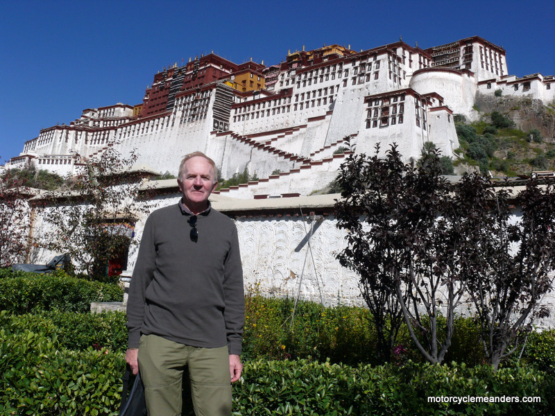
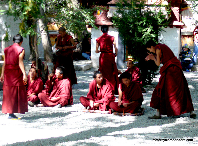
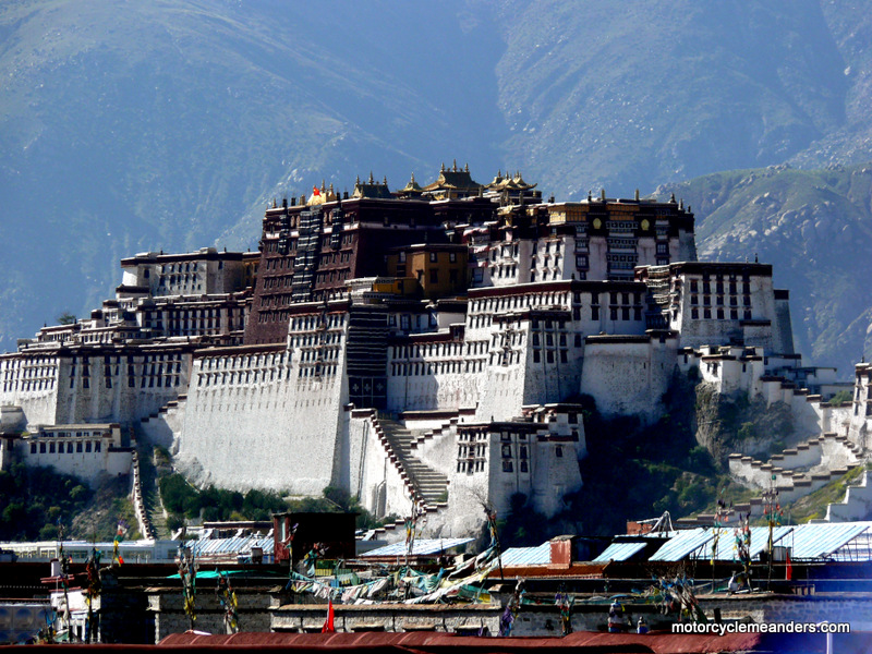
Our early morning excursion was followed by a tour of Potala Palace, dating from the 7th century and home and final resting place of many Dalai Lamas over the centuries. Potala Palace is the single most recognisable symbol of Lhasa and the whole of Tibet. It’s a special place that inevitably conjures up so much of what constitutes Tibet. We then visited Sera Monastery just on the edge of the city. It dates back to 1419 and is the second biggest monastery in Tibet. It’s an operating monastery so had monks performing rituals and practising their debating of theology and philosophy. That was an interesting spectacle. Finally we spent time in Barkhor St Market – consisting of a wide square with a temple crowded with pilgrims and lots of side streets with every item of local manufacture, predominantly religious items, antiques and handicrafts. Part of that time was enjoying coffee at a roof top cafe from which we had a totally unexpected but memorable view of Potala Palace across the roof tops.
At a relatively low 3700m, Lhasa sits astride river flats in a valley, so there is a sensation of heading out of Lhasa along the flats of the Yarlung River, following its wide river bed as it meanders through bright yellow autumn colours, before, soon enough, leaving the river flats and diverting onto the high plateau to rejoin the river and highway next day at Shigatse.
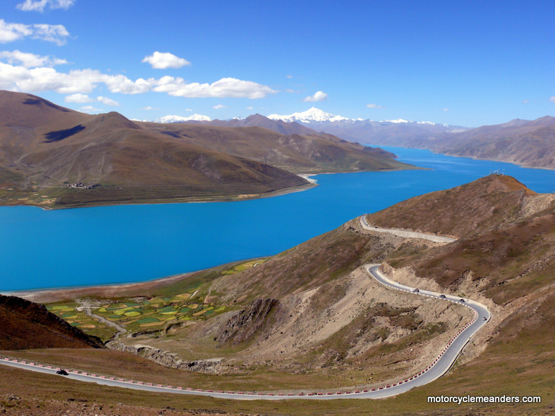
Although Khamba La was reached almost imperceptibly, it was unmistakably the top of the pass if only for the spectacular view on the other side of the luminescent, blue-green Yamdrok Lake. The second pass, Karo La at 5074m, was an even shorter ride to the top, with hardly a sharp turn. Obviously the height of the plateau between the passes is quite high. At Karo La, a glacier distinctively hangs onto the mountains above the top of the pass. The rest of the day’s run into Gygantse (pron something line Jung-tse) was across by now a higher part of the Tibetan Plateau than Lhasa as the road ambled along a broad valley between rising hills and past small typically Tibetan hamlets.
A We then headed for Shigatse, Tibet’s second largest city after Lhasa.
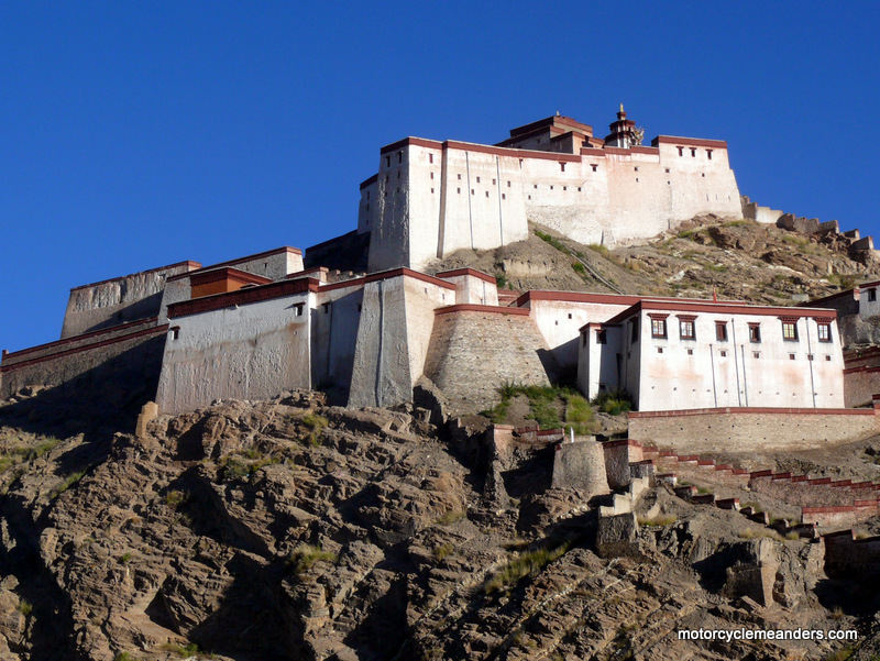
The centrepiece of Shigatse is the Tashilhunpo Monastery founded in 1447. It is one of the largest functioning monasteries in Tibet. It’s a huge complex spread along a hill side and consists of several golden-roofed chapels which house the remains of many of the Panchen Lamas (the heads of a sect of Buddhism). Shigatse’s other notable feature is the imposing castle of the Shigatse Dzong. It’s a smaller version of the Potala Palace. It’s not open to the public so we had to settle of photos taken from the local market. Across the Highest Pass of the Tour
But back to Shigatse. From Shigatse we rode through similar flat plains that we had crossed the day before: lots of farms and farmers, tractors pulling trailers of harvested crops along the road. After about 70km, the side walls of the valley began to converge bringing an end to the wide plains. However, as they converged, it became evident that they had left a gap which the road could slip through into a much narrower valley but one that still supported some farm activity.
One valley led to another until it was evident that the side walls of the valley were now converging inexorably with no way out. This would necessitate a climb up the sides of the valley winding back and forth until reaching the first pass of the day, Simi La at 4500m.
Further along the highway came the significant town of Lahtse where there is a major split in the road, with one arm heading North West to the far reaches of the Tibetan Plateau and another heading South West towards Mt Everest and Nepal. We paused at the intersection waiting for the support vehicles and the inevitable paper work that goes with frequent check points. We soon became the centre of attention of a group of young tourists from Shanghai fascinated by our journey and mode of travel. After Lahtse, we wound our way along rivers, through valleys and up and around the bulging hills that brought us to the highest pass on the Friendship Hwy between Lhasa and Kathmandu: Gyatso La at 5250m. We had light rain on the way up and sleet floating around at the top. Unfortunately, cloud prevented seeing Mt Everest, which would have been our first sighting of it. But nobody told us we would need to walk 600m or so up a fairly steep hill to get the view. I’m not sure I would have done it even if the day was clear. Mt Everest Base Camp
Turning onto the Everest Base Camp road we left any semblance of sealed road for two days. In fact, at times – most of the second day – there was precious little evidence of a road at all: just rock and rocks and sand.
I should divert briefly to explain that “Everest” is a British-bestowed name dating from the time of “British India.” Nobody at the time told the Tibetans that; and they still call it by the name they have presumably called it for generations long before the British had built their first ship: Qomolangma (pron something like chew –moo- loong – ma).
Getting round thickly piled rocks and sand on apexes of switchbacks is no easier going down; and there were 54 of them before we entered the Rongbuk Valley, with its high walls, sandy-bedded river and small, isolated Tibetan villages. The gravel road took us almost sneakily back up to around 5200m by the time we reached the “Qomolangma Base Camp” as the welcome signs announce it. Just short of the base camp is Rongbuk Monastery. Historical references place a monastery or places of worship here hundreds of years ago, although the present monastery was built in 1901 and has been rebuilt since because of fire. It looked tired and desolate; lacking the sparkle and colour of other monasteries we saw. Adjacent to the monastery as an annex is a rectangular, stone, single storey building that provides accommodation and meals to travellers. We would come back to it for the night; but for now we rode another few kilometres to the first of the Everest Base Camps.
We could ride only as far as the lower Base Camp. After that small buses take entry-paying tourists to the upper Base Camp. From there you seem to be unrealistically close to the highest mountain in the world; and we got to appreciate that spectacle as the clouds graciously skirted across and around it, but leaving frequent openings long enough to feel overwhelmed by its might and grandeur. You couldn’t help but feel mesmerised trying to absorb the wonder: this is Everest – I pondered as I sat on the edge of a mound and let the reality seep into me, allowing my mind to use a name that had more familiarity to it than its “true” name of Qomolangma. Next morning, having fought my way from under a doona and any number of thick blankets (all of which were necessary to keep warm in our totally unheated, bathroomless, stone-walled cell), a wander past the frost-covered bikes to the outside of the annex rectangle provided a stunning reward. Taking advantage of the early morning, dustless, chilled, clear air, Everest was revealing itself entirely, having cast aside all semblance of the modesty cloud cover might provide. The massive mountain opened up and beckoned one to pay homage. Thank You, Everest!
We certainly got off the road and followed one of innumerable but barely discernible tracks, as we had done on the way in the day before; I had thought then the reason was because, rough as they were, they were better than the road. It quickly became obvious that the tracks (I don’t think anyone necessarily followed the same track as the person ahead) were getting rougher and less discernible with every kilometre; and seemed to be going in no clear direction. We eventually crossed the river (by bridge thankfully) indicating that we had by then diverted from the road along which we had come the day before.
The relief of freeing ourselves from the bone-jolting sea of rock waves and eddies was to be followed by more readily visible wheel tracks that deceptively camouflaged sand of varying viscosity and depth. Relentlessly the tracks took us across (or through) deep sand patches, loose stones, a couple of water crossings and through traditional villages. A significant consolation was the spectacular view looking over your shoulder as we moved away from the clump of Himalaya’s highest peaks We finally re-joined the Friendship Hwy at Old Tingri in agreement that we had just had the most exciting and satisfying two days riding to Everest and back.
As in any other place where there are side tracks, detours or “short cuts”, there’s never one single track to follow. There’s a multiplicity of tracks each undoubtedly formed by vehicles who were impatient or thought they had a better idea! There was no logical way of selecting the best or shortest or smoothest track; it was all guess work. It was at the start of the diversion that we encountered an unexpected spectacle: a group of like-minded tourists, but in their case on motorbikes with sidecars. The bikes were Chinese knock-offs of an early German model of the currently popular BMW ‘boxer’ engine. The pass boasted sights of the smallest of the Eighteen Thousanders, but, as with earlier passes, cloud hindered any view of the mountain. Nyalam: The Gate of hell
Next morning, we were to tackle this gorge that had earned Nyalam the title of the Gate of Hell. Apart from a short uphill ride to get out of town, we had an unending downhill run along almost perpendicular valley walls spotted with waterfalls across the valley and water flows across the road. In contrast to the dry, barren rocky landscape we had been riding through, everything on this final downhill run was lush green. It was a very pleasant but cautious ride through several wet and slippery corners.
The fast declining road leads to the twin, scruffy, border towns of Zhangmu (China) and Kodari (Nepal), bustling with tourists, traders and Nepali porters; both towns clinging to the sides of a precipitous ravine joined by the rattling bridge that serves as the border crossing. We struck an unexpected delay here: it was some sort of holiday and the Chinese customs official needed to clear the bikes out of China had slept in, presumably after a celebratory night! – and then we encountered some difficulty negotiating a mutually agreeable entry arrangement for the entry of the bikes into Nepal. All in all, we lost several precious hours ‘hanging around’ on both sides of the border. Final Run to Kathmandu
Our run through the wild, sprawling metropolis of greater Kathmandu, with its wall to wall traffic of buses, trucks, cars, 4x4s and motorbikes, was all in the dark. No street lights; just headlights, but not consistently – lots of vehicles drive without them! Our strategy was to stay bunched up tightly with a sharp eye on the riders ahead. It almost seemed a miracle that we all made it to the hotel in this totally confusing cacophonous nightmare. It was celebrations all round that we were safely in Kathmandu. It was late, very late; but not too late for a cold Nepali beer.
Photo Album |
 Driving from the airport into Lhasa is a very special feeling brought about by a conglomerate of thoughts, feelings and events. Tibet has a long fascinating history of documented centuries; a rich cultural and religious soul; symbolic places such as the Potala Palace; and, of course, we had the expectation from the outset of riding across the Tibetan Plateau with its plains, high passes, Everest Base Camp and the crossing of the Himalayas into Nepal.
  The flight from Kathmandu to Lhasa was only an hour, but the time difference is 2 and a quarter hours, despite the longitude being much the same (China has only one time zone across a vast distance of longitude). The flight, of course, crosses the Himalayas which are the border between China and neighbouring countries to its south: Pakistan, India, Nepal, Bhutan. Unfortunately, it was very cloudy but that didn’t stop a few high, sharp, snow-covered peaks protruding through the clouds making one wonder if the plane is comfortable in flying higher than the 8,000m that several mountains in the area exceed.
 Our initial plan had allowed for three full days in Lhasa, but because of having to change our plans to accommodate visa restrictions, we had to settle on just one day along with the rest of the tour group.
 First we had important business to attend to: a practice ride of a couple of loops round the streets of Lhasa –early enough to avoid the traffic. On three previous tours riding in India, Nepal and Bhutan, the bike had been the Royal Enfield Bullet – that notoriously “misconstructed” machine which has the brake lever on the left, the gear lever on the right and the gear box upside down! I was missing it already as we were introduced to the Royal Enfield Desert Storms, with conventionally mounted levers and gear box.
 In reality, the whole of Tibet – or, as it’s officially called “Tibet Autonomous Region” or “Xizang Autonomous Region” – stretches across the vast Tibetan Plateau, the world’s largest and highest plateau with an average elevation in excess of 4500m.
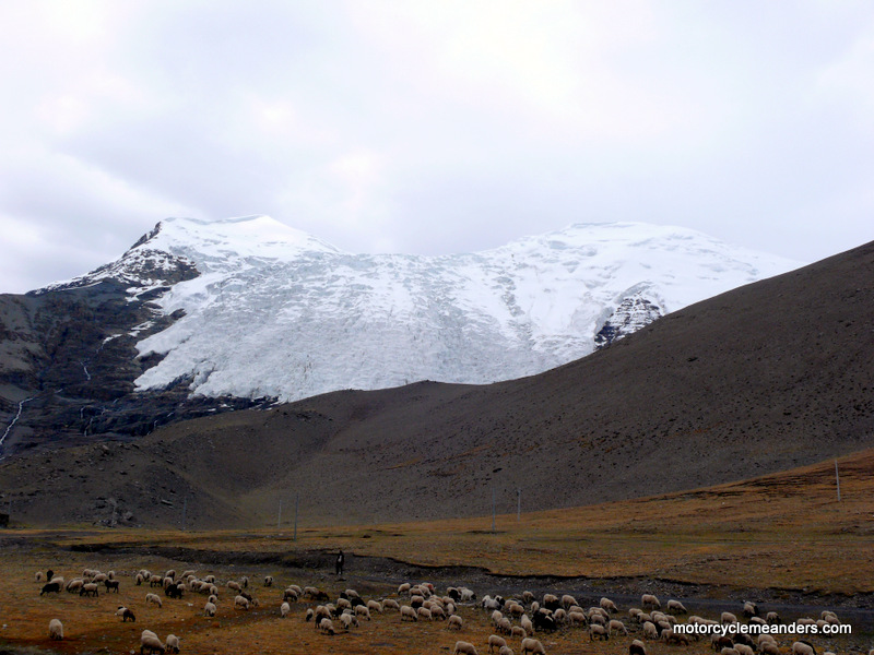 Once we left the river flats, it was the start of the climb to the top of the first pass of the tour: Khamba La at 4800m. There were some pleasant, tightish turns but not like the switchbacks on the Himalayan passes of India or Bhutan. The striking feature was the rapidity with which we reached the top of the pass. Then it became evident why: the Tibetan Plateau is higher on average than the highest pass crossed in Bhutan. The highest pass in Bhutan was 3800m.
  With one exception (on the road to Everest Base Camp), despite the elevation of several passes over 5000m, there wasn’t the same sense of conquering them as there was in the Indian Himalayas. In fact, with a few, you might have easily missed the top of the pass were it not for the twisted array of prayer flags fluttering in the breeze.